Share
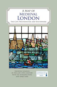
A map of Medieval London: The City, Westminster and Southwark
Caroline Barron (Author)
·
The Historic Towns Trust
· Map
A map of Medieval London: The City, Westminster and Southwark - Caroline Barron
£ 9.89
£ 10.99
You save: £ 1.10
Choose the list to add your product or create one New List
✓ Product added successfully to the Wishlist.
Go to My WishlistsIt will be shipped from our warehouse between
Tuesday, May 28 and
Wednesday, May 29.
You will receive it anywhere in United Kingdom between 1 and 3 business days after shipment.
Synopsis "A map of Medieval London: The City, Westminster and Southwark"
A full colour map showing London about 1270 to 1300 - its walls and gates, parish churches, early monasteries and hospitals, and a growing number of private houses. The city's streets and alleyways had been established. Dominating London are the Tower of London in the east, the old St Paul's Cathedral in the west and London Bridge in the south. Up-river in Westminster, the abbey and the royal palace had been well established, and the great Westminster Hall is very evident. London's playground in Southwark was beginning to grow.
- 0% (0)
- 0% (0)
- 0% (0)
- 0% (0)
- 0% (0)
All books in our catalog are Original.
The book is written in English.
The binding of this edition is Map.
✓ Producto agregado correctamente al carro, Ir a Pagar.

