Millions of books in English, Spanish and other languages. Free UK delivery 

menu

0
  • argentina
  • chile
  • colombia
  • españa
  • méxico
  • perú
  • estados unidos
  • internacional
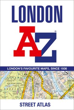
portada London A-Z Street Atlas
Type
Physical Book
Author
Language
English
Pages
464
Format
Paperback
ISBN13
9780008663490

London A-Z Street Atlas

A-Z Maps (Author) · Geographers' A-Z Map Company Ltd. · Paperback

London A-Z Street Atlas - A-Z Maps

Physical Book

£ 8.09

£ 8.99

You save: £ 0.90

10% discount
  • Condition: New
It will be shipped from our warehouse between Thursday, June 06 and Friday, June 07.
You will receive it anywhere in United Kingdom between 1 and 3 business days after shipment.

Synopsis "London A-Z Street Atlas"

First published in 1936, this iconic atlas is a trusted means of finding your way around the capital city. The main mapping extends beyond Central London from Heathrow Airport to Chingford at a scale of 2.88 inches to 1 mile, featuring postcode districts, one-way streets, the Congestion Charging Zone and Low Emission Zone. The large-scale street map of Central London - at a scale of 5.75 inches to 1 mile - covers Regent's Park and Shoreditch, Chelsea and Vauxhall, Hyde Park and Bermondsey. A comprehensive index lists streets, selected flats, walkways and places of interest, place, area and junction names. Additional healthcare (hospitals, walk-in centres and hospices) and transport connections (National Rail, London Tramlink, Docklands Light Railway, London Underground and Overground stations, and River Bus pier) are indexed as well.

Customers reviews

More customer reviews
  • 0% (0)
  • 0% (0)
  • 0% (0)
  • 0% (0)
  • 0% (0)

Frequently Asked Questions about the Book

All books in our catalog are Original.
The book is written in English.
The binding of this edition is Paperback.

Questions and Answers about the Book

Do you have a question about the book? Login to be able to add your own question.

Opinions about Bookdelivery

More customer reviews